Mountains in the Making
A common misconception among travellers is that Norway’s peaks are a single, unbroken chain raised by one recent collision. When we inspect the rocks along Hardangervidda and Jotunheimen, we uncover a two-part story separated by hundreds of millions of years: an ancient Silurian continental collision that welded the rock fabric together, followed much later by vertical uplift and deep erosion.
The Baltic Foundation and the Ancient Peneplain
Begin at the lowest structural level visible along the western fjords or across the sweeping tableland of Hardangervidda. The bedrock beneath your boots—granites, migmatites, and banded gneisses—crystallised between 1,750 and 900 million years ago during the Gothian and Sveconorwegian orogenies.
By around 550 million years ago (the start of the Cambrian Period), erosion had ground those primeval mountains down to a nearly flat, sea-level surface known as the Sub-Cambrian Peneplain. Even today, when you stand on Hardangervidda at 1,200 metres above sea level and gaze across tens of kilometres of remarkably flat horizon, you are looking at that exhumed ancient plain, lifted intact into the sky.
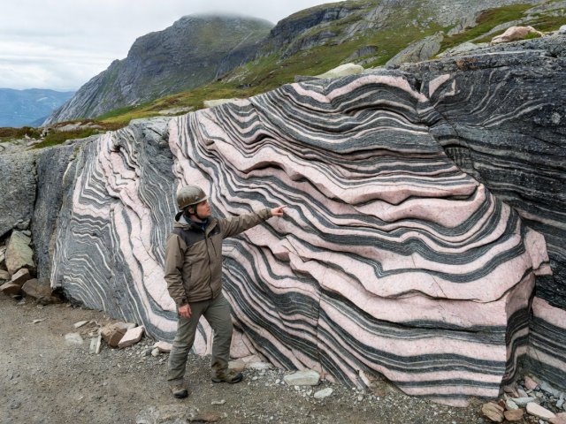
The Caledonian Orogeny and Thrust Nappes (Skyvedekker)
During the Early Palaeozoic, an ocean called the Iapetus Ocean separated Baltica (ancient Scandinavia) from Laurentia (Greenland and North America). Muds, sands, and volcanic island arcs accumulated on that ocean floor. Starting in the Ordovician and climaxing in the Silurian Period (~430–400 Ma), the Iapetus Ocean closed and the two continents collided head-on.
In the field, you can verify this collision at places like Haugastøl or along the steep walls of Aurlandsdalen. Above the hard Precambrian basement sits a dark, crumbly layer of Cambrian alum shale and phyllite. Directly on top of that soft phyllite rests a massive, thousand-metre-thick cap of ultra-hard Proterozoic gabbro and anorthosite—the Jotun Nappe.
Observation: Look for a sharp horizontal line on valley walls where dark, flaky, easily eroded rock (phyllite) supports a sheer, overhanging cliff of massive crystalline rock. At eye level in roadcuts, the boundary rock is stretched into ribbon-like bands (mylonite).
Interpretation: The soft shale acted like grease on a slipway, allowing a continental slab tens of kilometres thick to slide more than 200 km southeastward without shattering into rubble.
Term Definition: Eclogite (High-Pressure Metamorphic Rock)
In the Western Gneiss Region (around Nordfjord and Sunnmøre), continental crust was forced 70 to 120 km down into the mantle during the Caledonian collision. Under immense pressure, basaltic pockets transformed into vibrant red garnet and green omphacite pyroxene—a dense rock called eclogite, later brought back to the surface when the mountain belt collapsed under its own weight.
Why Are the Mountains Still High Today?
Here is the paradox every careful student asks: if the Caledonian mountain range formed 400 million years ago—making those rocks older than the dinosaurs—why hasn’t weather worn Norway completely flat? In fact, it nearly did. Throughout the Devonian, Permian, and Mesozoic eras, the towering Caledonides collapsed and eroded down into low-relief rolling plains and rift basins.
During the Paleogene and Neogene periods (roughly 60 to 20 million years ago), as the North Atlantic Ocean rifted open between Norway and Greenland, the western margin of Scandinavia experienced broad epirogenic dome uplift. The worn-down Caledonian root zone was arched upward by 1,500 to 2,500 metres.
Why do Galdhøpiggen (2,469 m) and Glittertind stand taller than surrounding plateaus? Because the Jotun Nappe is composed of dense, coarse-grained pyroxene granulite and gabbro. While rivers and glaciers stripped away the softer surrounding schists during the last 2.6 million years, the tough gabbro core resisted erosion, standing proud as a rugged alpine massif.
| Geological Unit | Age of Rock | Key Minerals / Rock Types | Field Example Locality |
|---|---|---|---|
| Upper Allochthon (Seve/Köli & Ophiolites) | 500–430 Ma | Greenstone, pillow lava, serpentinite | Leka Island, Dovrefjell margins |
| Middle Allochthon (Jotun & Valdres Nappes) | 1,650–900 Ma | Gabbro, anorthosite, mangerite, conglomerate | Galdhøpiggen, Hurrungane, Bygdin |
| Lower Décollement Zone | 540–440 Ma | Alum shale, phyllite, orthoquartzite | Hardangervidda mesas (Hårteigen collar) |
| Baltic Shield Basement (Autochthon) | 1,750–950 Ma | Granitic gneiss, migmatite, granite | Lysefjorden, Romsdalen lower walls |